MagTool
Download MagTool V3.2 (released 17 September 2024) here
MagTool V3.2 Overview
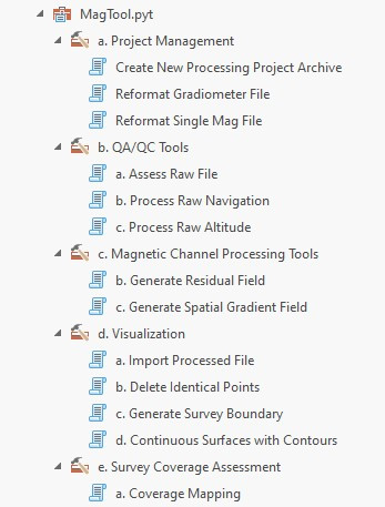
Currently there are thirteen individual utilities within this Python Toolbox. They are categorized as follows:
a.Project Management: Generates a project archive with workspace pathways utilized by downstream scripts. Uses pandas Data Frame functions to reformat raw single magnetometer and/or gradiometer files into an ASCII file schema streamlined for processing.
b.QA/QC Tools: Examine raw data files for fliers, gaps, and noise prior to processing. Execute cleaning tasks (de-spiking, smoothing, interpolation) on navigation and altitude sensor channels. Iterate results into expanded ASCII file outputs. Uses Matplotlib to generate time-series graphs for data QA/QC.
c.Magnetic Channel Processing Tools: Multiple methods for processing raw total field magnetic data to enhance detection of signals from ferromagnetic objects. Options include signal processing tools from SciPy/pandas (Residual Field) and geospatial filtering via NumPy arrays (Spatial Gradient) to compute new output fields. Both methods can be used simultaneously. Uses Matplotlib to generate time-series graphs for data QA/QC. Completion of this step results in 'final' processed data file in ASCII format.
d.Visualization: Uses ArcPy to import processed data as raw points and compute sensor tracklines. User-defined parameters establish a coverage area used to clip rasters generated for raw and processed magnetic data fields. Offers multiple interpolation options for raster surface creation, contours results at user-defined intervals.
e.Survey Coverage Assessment: Performs a series of geospatial analyses to determine theoretical levels of survey coverage based on raw data point geometry, sensor altitude, sensor noise, and user-defined magnetic moment values. Outputs include raster surfaces to visualize and statistically describe coverage levels per input parameters.
Notes on utilization
This version remains under development. No XML files containing tool descriptions or help were prepared at the issuance data above. Version tested on ArcGIS Pro 3.0.2; requires Spatial Analyst and 3D Analyst extensions.
